Hello! I want to make an app, using a map of the city where I live.
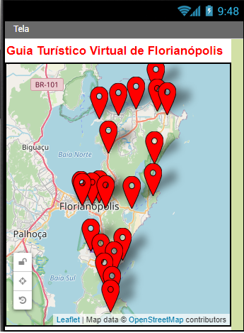
You can see in the attached file, that I put the map of the city where I live, and I put the markers. And I saved everything.
However, when I go to run on my cell phone, the map of the city of Boston appears. And when I go to the map of the city where I live, the markers that are in this photo DO NOT appear. But it SHOULD appears.
Please, how can I make that, when the application is run on my mobile, the map of the city I'm in already appears directly at first, and all the markers appear, as they are in the attached file?
A possible quick fix is to type -27.59350, -48.558540 in
When you use the geocoordinates for Florinapolis in the CenterFromString, you should see your map 'center' If you only get close to what you want, use the coordinate of the 'center' of your map pins.
Thank you very much, SteveJG. It worked to show the map of the city where I live at the first.
Please, how to show the markers?
You can see in the attached file that I put the markers, but running in a cellphone, the markers does not appear, but they should appear.
It depends on your Project code. Are you using design time Markers or run time Markers? If the coordinates of the Markers are pre-coded, you should see them immediately; if the coordinates come from a file, perhaps a csv; you have to provide code to load the file in your Screen1.Initialize event handler Block.