Hello, with this extension i can get indoor position x,y based on Beacon rssi:
https://bit.comp.polyu.edu.hk/
How can i create and indoor map to show the user position and eventuali manager the position of Beacon device? Can someone produce code example? Thanks in advances
Welcome Michele.
The extension outputs to x,y coordinates so several ways come to mind
-
direct x,y plotting to a Canvas component
-
another way to use the Canvas Place image on canvas at X, Y coordinates (negative x,y values from esp32)
Thanks for the reply.
Can you provide me sample code ? I beginner with appinventor, i use Basic4Android.
I neet to load a map and on touch it position at x,y a beacon and then show me the direction of a know x,y beacon. Thanks in advanced and sorry for my hard request.
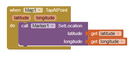
With App Inventor you can use
- the Map component to load a map (It uses OpenStreetMap map tiles).
- use this Block to touch on a point on the map and capture its coordinates to a Map Marker (what you call a 'Beacon')
-
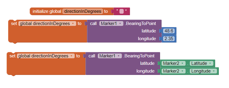
to show direction to other lat,lon coordinates (upper image); to other Marker (lower image)
-
a complex example of something similar National Park Tutorial (Markers) updated
-
a Beginner
 Here are some resources to help you learn to use the AI2 tools. A very good way to learn App Inventor is to read the free Inventor's Manual here in the AI2 free online eBook App Inventor 2 Book: Create Your Own Android Apps ... the links are at the bottom of the Web page. The book 'teaches' users how to program with AI2 blocks.
There is a free programming course here Course In A Box and the aia files for the projects in the book are here: App Inventor 2 Book: Create Your Own Android Apps
How to do a lot of basic things with App Inventor are described here: How do you...? .
Also look here App inventor español. Offline. Tutorial. Ejemplos. Instalación. Códigos. Juegos. Curso gratis de App inventor. and here Tutorials for more tutorials including Imagnity.com List Tutorial, Mirrored - @Saj
Learn about components Component Reference
and visit the Library The MIT App Inventor Library: Documentation & Support Help>Library on the MENU