Contour Maps with App Inventor

German asked this question in a topic about the BING Map extension:

"I want to ask you a DETAIL of this extension or if you know about this.

I have searched in generally and i didn't find any solution for this.
If you want to make "a contours maps" app, not google or microsoft, provide a way to make it from what i search it.
Do you know if bing let you download or make it (but not showed in public but in the detail of the apis for the maps?
I search in yandex and i didn't find how to do it too.
I know, the google maps let you do it, LONG AGO, but now i cannot find a way to do it.

The contours lines are lines of same ALTITUDE and the utility is for Geography-Geology and Military, maybe there are other uses but this are all i know for sure.
I want it for academical geological uses.
Any help you provide will be welcome.

Thanks."

Here is a link for contours in Argentina using Google Maps German.

Google Maps You need to set Terrain map set and it only shows at some map zooms


.

Regarding BING contours, this might be interesting Bing Maps V8 Interactive SDK

BING does not appear to have an alternative tile set like Terrain (usually contour maps) like Google and OpenStreetMaps. However it can do this Base Map Tile Layer Example - Bing Maps | Microsoft Learn at least for the USA.

Hello SteveJG.

Thanks for replying.
Well. I have problems with the google earth for this.
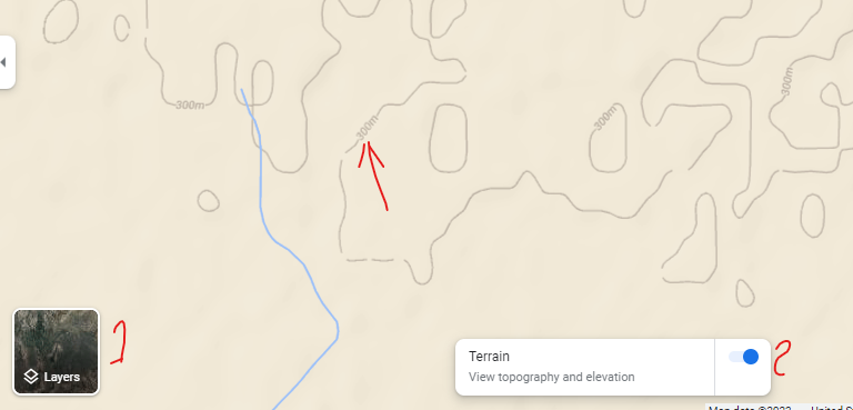
Some time ago, the google earth LET YOU put the limit for the (cota), the reference line, and let you select the interval of the lines, plus the lines were LINES, not a bitmap file as TERRAIN as layer.
I know because i have later images downloaded as vectors (converted to bitmaps).
When i was making my tesis, i make a map of the COMECHINGONES hills-mountains region of Cordoba state, Argentina.
And i could select all i say, the interval in the lines, directriz line in other color (like bold lines), and more options. NOW this adds have been removed. Only every 100m and as a bitmap is the default now.
And for example for my current state of Santa Fe, i cannot recognize anything for almost 100km because is a flatland, this state is a PAMPA, no hills at all, so, i cannot manage to do it with google earth.
BUT.
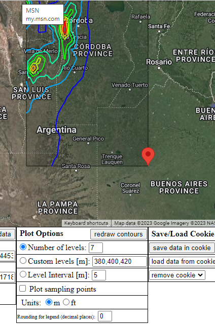
There is always a but, i found i can do it with USGS terrain model and a product called AXIS maps. (Axis is FAR TOO GOOD, but it have some issues, like to be TOO slow for pc or android devices).
So. I was looking for alternatives. A service who let me to add the interval of the lines, get bigger or in other color -some lines- like directriz lines (1000, 500, 250, 100m) solid color or hypsometric tints.

Here are the examples for real. (centered in my town).

https://contours.axismaps.com/#12/-33.4636/-61.4660

Google Maps

For google i add the ** for not load in the page, because it's too much to load.

Again, the 1st is the best option, but i didn't find a way to inject my data in the search engine, and a way to select the options.
In the axis product, i can select all in a pc but i cannot edit in android.

Why is all of this?
I was thinking to make an app for academical purpose. With terrain maps, and as a walking (tracking) app.... but with steps 1st ( [using step meter]) and 2nd as measured with (meters with GPS).
This is like a Transecta app, more used in small scales and for Biology or Botanical use. (and add every some steps what you find). Example: 5 steps from the last point with a direction of a compass, i found a rock or a flower with some characteristics, 15m with some other direction, another detail of rock or plant....

Well. That's the idea.
Sorry for add this to KevinKun post. I was looking info or a way to do this.
Seems to be more complex to do it.

(by the way, the way of google earth show the data in the map, even in far away places, not in urban areas, show too much data of the places. TOO MUCH, and i need clean map, with no indications at all. Nothing more the data i need to add. And google doesn't HELP ME :slight_smile: with all the overdose of data they show.

AGAIN. Thank you Steve for the info and sorry KevinKun for asking this here. Remove my questions if you like, they are not relevant for the purpose of the post.

I just placed the posts regarding contour maps in a more appropriate space. :wink:

Quite a few years ago I used a routine to contour map values based on field data at various location using Delphi (Object Pascal) to make a contour map. It used an algorithm called CONREC. You might find the algorithm useful although it has not yet been ported to App Inventor Blocks. CONREC - A Contouring Subroutine . If you do this, you have to provide the elevation information for control points you provide. Yes, it means you have to make the map from data . I am not sure App Inventor can do this; if it could it would involve the Canvas and be of limited use. :cry:

Try this tool: https://contourmapcreator.urgr8.ch/

Thank you AGAIN Steve for all of your support.

Well. I can do it adding a layer of surfer map to the google maps, but is over processing and could be for one project (1 place), but if you wish to share the app, for many places, it's impossible of slow. Adding for each place, a map is not the idea.
And as i tell you. Is for small scale.(less than a 1km, but in places with a BIG SLOPE, could be a REAL SOLUTION for this kind of application).
Example for this a place with 300m of slope and you must work at 150m, you have 150m up and down from your position. In google map, could be not seen.
And the oposite, i need to make a map with 1m of elevation, for water movement in an urban area, doesn't show at all (in this case, you depend in making YOUR own maps, with Levels and Teodolitos.
I am looking to get easier the work on the field. And doing a map for each work is TERRIBLE SLOW. Is the way the things are doing NOW. And must be a way to produce this. -the best example is the axis product i share- but for some strange reason, is very difficult to inject the data.

Superb clean maps, easy to understand, you can choose the details of the lines (bold, color, etc).
But, i cannot manage to work with them from AI2.

Again, Thank you. I continue in debt with you. Maybe the time let me help you for a change, in the future :slight_smile: