I'm a beginner and I'm not sure how I can incorporate maps into my project using the mit app inventor. The whole idea of the project is to find nearby bus stops, metro stations, and other people who are using the app who are willing to carpool. It should also incorporate the destination the user wishes to go to and how long it would take if they took the metro or bus.
Welcome.
An extremely ambitious Project for a beginner.
Currently probably possible only using the GoogleMap api and the Directions api.
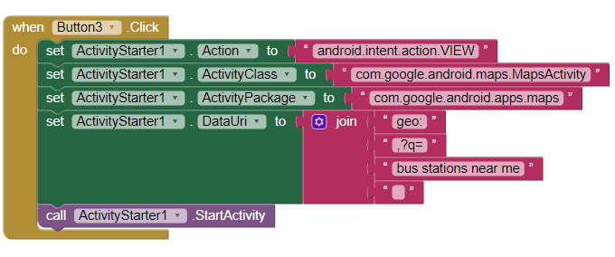
Load the FindPetShelters aia then substitute the pet shelter search for bus stations near me
This code will also work to find bus stations but without a LocationSensor requirement
carpool
perhaps this discussion will help. You will need an online real time database
great okay thanks!
How do I calculate/track the carbon emissions that were caused during transport when i incorporate google maps?
Perhaps relate the information in this chart which shows the estimated carbon footprint for each kilometer transported using various methods
There probably other methods you could use.