bonjour,
j'ai vu que la question a déjà été posée, et qu'il existe un tutoriel nommé :Comment afficher les marqueurs d'exécution de la carte, calculer les distances, déterminer le plus proche (Redirecting to Google Groups)
Mais je n'y comprend rien.. :transpiration:
j'essaye d'afficher une carte avec de nombreux marqueurs et je souhaiterais qu'il soit tous cliquable afin de récupéré et utiliser les informations du marqueur sélectionné
quelqu'un pourrait m'aider ? merci
did you download and load the National Parks_2 aia file and load it into your Projects? There is an explanation showing how to use the Map Blocks
the code shows how to add many markers to your map using a csv file. What does your csv file look like? How the csv is structured dictates how you code this.
the code shows how to make each Marker clickable
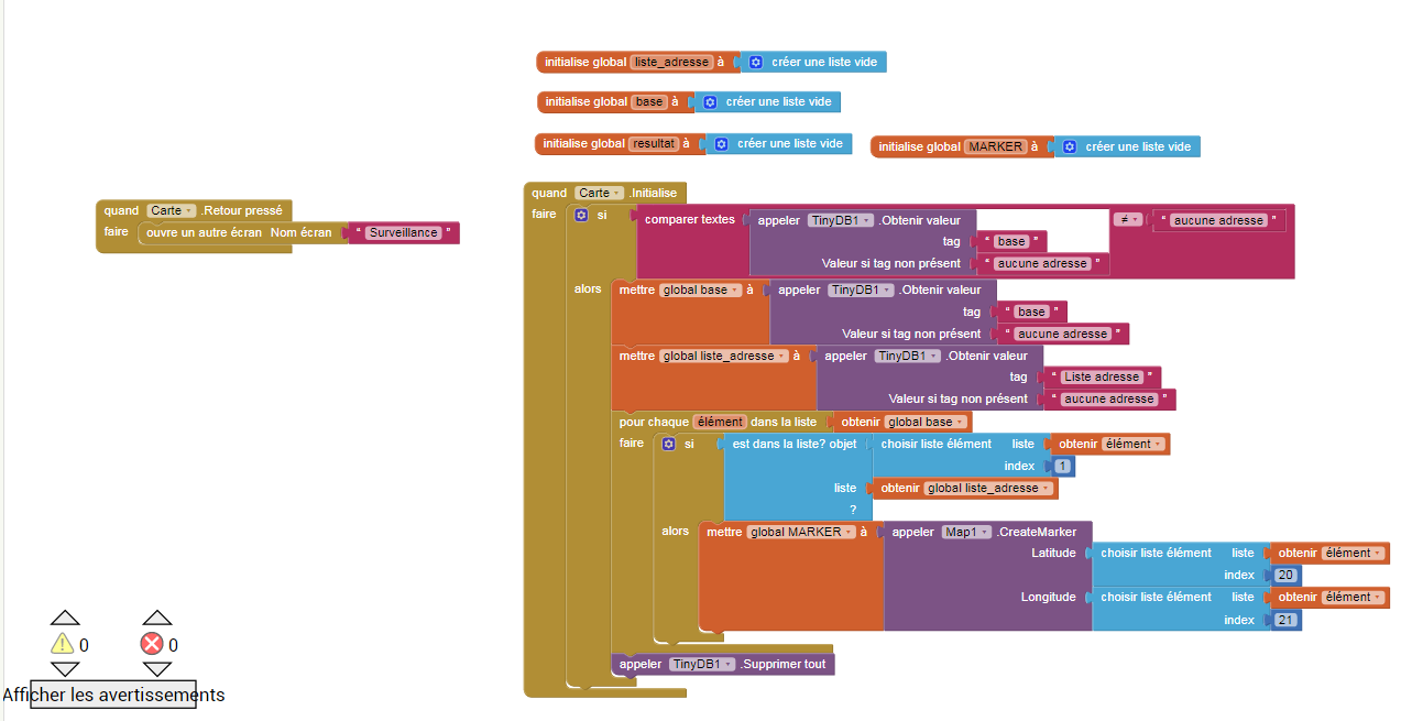
your code indicates you want to use a TinyDB to load the location information; what you do depends on what you stored in the TinyDB Tags. Unfortunately since you did not share that information, no one can help you.
you are using multiple Screens. Using multiple Screens makes using an app like this very difficult to code. I suggest you use virtual screens.
have you read the documentation for the Map components? Map components explains what each of the Blocks in the tutorial does.
Rather than immediately making an app that loads/saves data to a TinyDB that you make a simple Project using a csv to simply create a Map with your locations. Once you make the map; post your code and someone will provide specific advice showing how to display information in map bubbles.
Merci de votre réponse, je n’avais pas comrpis qu’il fallais telecharger le fichier national_parc_2
mon fichier csv est a la base un fichier sheet ou est stocké l’adresse de mes clients ainsi que leur oordonnées : latitude + longitude
je ne connais pas les écran virtuel, en cherchant sur le forum j’ai cru comprendre que le principe était d’afficher ou cacher certain arrangement vertical ou horizontal… c’est bien ca ?
j’ai lu la documentation Map… mais je n’ai pas tout les bloc mentionnés…
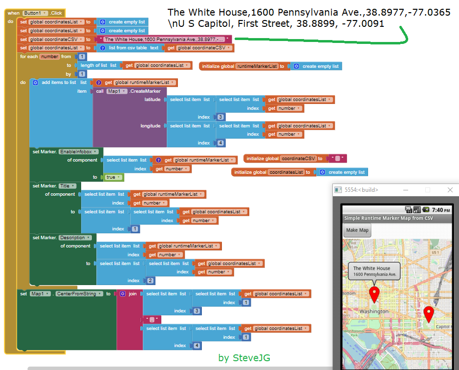
Is this example what your csv looks like? or does it look different? What does the csv data look like? If it is not similar; you will have to convert it or use a different example. What you do depends on your App Inventor coding skill level.
Building Apps with Many Screens
Yes you do have all the Blocks. It appears you do not know where to look.
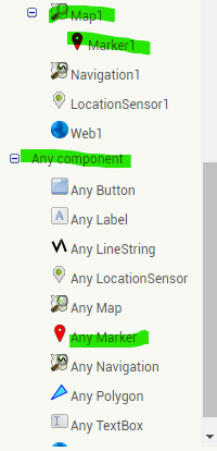
You need the Map, Marker and AnyComponent Blocks
Here are some resources to help you learn to use the AI2 tools. A very good way to learn App Inventor is to read the free Inventor's Manual here in the AI2 free online eBook App Inventor 2 Book: Create Your Own Android Apps ... the links are at the bottom of the Web page. The book 'teaches' users how to program with AI2 blocks.
:craintif: Merci je n'avais pas penser a chercher ANY MARKER dans n'importe quel composant...
je le cherchais dans MAP...
merci pour toute ces informations, je vais prendre le temps de tout regarder
il existe aussi une astuce pour mettre les cours app inventor fichier pdf en langue francaise ? mon niveau en anglais est tres moyen, mais il y a plein d'image, ca devrais aider
When you are able to show a map with two locations, you are ready to add as many locations as you like in the csv. The csv can be coded directly into the Text box (as is done with this example) or loaded using a File component and a csv file in Media or other location (perhaps a GoogleSheet, using the Web component). Learn to use the Map component. Then you can start adding features.
Try this example. When it works correctly, save it then modify it to have the features you want and need Cael.
il existe aussi une astuce pour mettre les cours app inventor fichier pdf en langue francaise ? mon niveau en anglais est tres moyen, mais il y a plein d’image, ca devrais aider
You can use Google Translate... it will translate Web pages.