I've uploaded a file under the media tab that's JSON but I can't seem to get the data from it out. Could anyone direct me as to how to read it?
Can you also paste the contents of the JSON file here please?
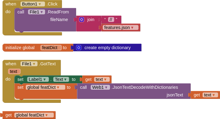
I don't have any blocks yet, I only have a file uploaded named trails.json.
Can you show me which blocks to use to put the path of the filename in?
{
  "type": "FeatureCollection",
  "name": "waypoints",
  "crs": {
    "type": "name",
    "properties": {
      "name": "urn:ogc:def:crs:OGC:1.3:CRS84"
    }
  },
  "features": [
    {
      "type": "Feature",
      "properties": {
        "ele": 37,
        "type": "Trail",
        "label": "Indian Trail"
      },
      "geometry": {
        "type": "Point",
        "coordinates": [
          -82.27596,
          31.053835
        ]
      }
    },
    {
      "type": "Feature",
      "properties": {
        "ele": 196,
        "type": "Trail",
        "label": "Skyuka Trail"
      },
      "geometry": {
        "type": "Point",
        "coordinates": [
          -85.3802369,
          34.9795203
        ]
      }
    },
    {
      "type": "Feature",
      "properties": {
        "ele": 935,
        "type": "Trail",
        "label": "Black Mountain Trail"
      },
      "geometry": {
        "type": "Point",
        "coordinates": [
          -84.0063018,
          34.6695353
        ]
      }
    },
    {
      "type": "Feature",
      "properties": {
        "ele": 721,
        "type": "Trail",
        "label": "Burrells Ford Trail"
      },
      "geometry": {
        "type": "Point",
        "coordinates": [
          -83.1615414,
          34.9395344
        ]
      }
    },
    {
      "type": "Feature",
      "properties": {
        "ele": 833,
        "type": "Trail",
        "label": "Chattahoochee Trail"
      },
      "geometry": {
        "type": "Point",
        "coordinates": [
          -83.8335163,
          34.7539816
        ]
      }
    },
    {
      "type": "Feature",
      "properties": {
        "ele": 398,
        "type": "Trail",
        "label": "Gryder Camp Trail"
      },
      "geometry": {
        "type": "Point",
        "coordinates": [
          -84.6452121,
          34.9606339
        ]
      }
    },
    {
      "type": "Feature",
      "properties": {
        "ele": 745,
        "type": "Trail",
        "label": "Three Forks Trail"
      },
      "geometry": {
        "type": "Point",
        "coordinates": [
          -83.211264,
          34.9845335
        ]
      }
    },
    {
      "type": "Feature",
      "properties": {
        "ele": 184,
        "type": "Trail",
        "label": "Falling Camp Trail"
      },
      "geometry": {
        "type": "Point",
        "coordinates": [
          -83.2598784,
          33.7623437
        ]
      }
    },
    {
      "type": "Feature",
      "properties": {
        "ele": 745,
        "type": "Trail",
        "label": "Bartram Trail"
      },
      "geometry": {
        "type": "Point",
        "coordinates": [
          -83.3271031,
          34.8664808
        ]
      }
    }
  ]
}
Thanks, resolved.
This topic was automatically closed 7 days after the last reply. New replies are no longer allowed.