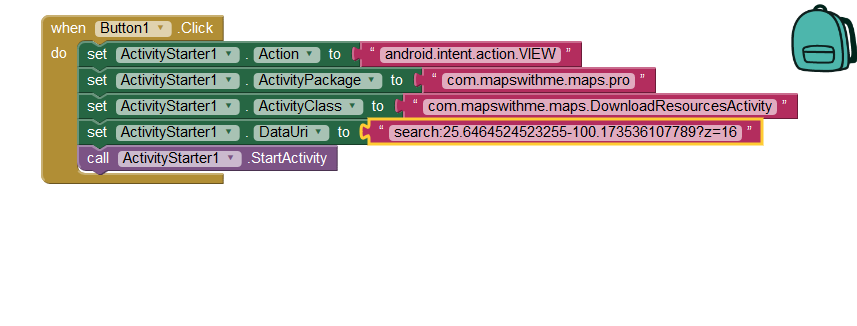
Здравтвуйте! Я использую в качестве карты Maps me, использую Activity Starter.Maps me работаеть нормально. Зашел на страницу API там код открытый: https://github.com/mapsme/api-android
только вот не знаю как использовать блоки Activity Starter чтобы получить ответ (гео или другие данные) после возарата в приложению. Потому что ответ (результат) пустой. Как мне получить из карты Maps me результат о широте и долготе или ещи другие с помощью Activity? Спасибо за ответ!
I am not familiar with MapsMe. It is a program to use offline maps. I assume you have the Pro version loaded on your Android. Most people will not.
You try to use the MapsMe api using intents. Intents are called with App Invenor 2 using ActivityStarter so that might work.
I have no documentation about how to use intents with MapsMe. I cannot find how to use intents using the link you provided. Your DataUri seems suspicious. Place a comma to separate 25.646… latitude and -100.175…longitude and see what happens. The standard way to represent a location is to use the latitude and longitude separated by a comma (for example, latitude,longitude)
Consider using the MIT Map component. The Map component can access cached OpenStreetMap tiles offline ( they tiles have to have been previously accessed on line at least once in the area you wish to see a map.). An app made with the Map component caches map tiles automatically so it is possible, in some circumstances, to use the OSM tiles without accessing the OSM server.
Спасибо, Стив, за подробный ответ, я работаю над приложением которое работает кмл файлами! А у компонента MIT Map пока нет такой возможности! По этому хотелось бы с помощью профессионального специалиста осуществить обмен данных между приложением AppInventor i Maps Me. То что написано в документации API самостоятельно не мог понять😔. Если помогли бы с разбором API было бы здорово!
У меня такая задача
1). Когда я нажимаю кнопку показать на карте, приложения по GPS координатам переданным мною показывает мое местоположение.
2). После выбора на карте MAPS ME конкретной метки и нажатие кнопки назад надо получить имя, широту и долготу выбранной на карте метки.
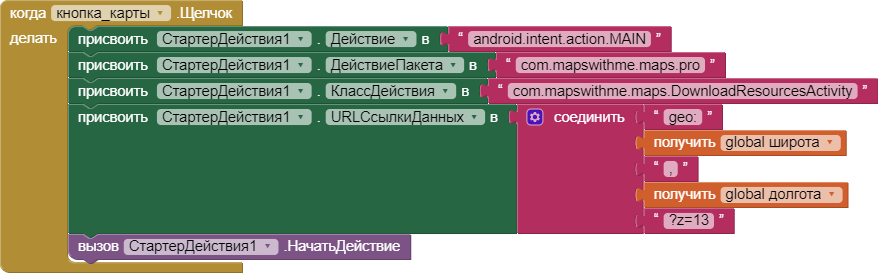
3). Я исправил ошибки, которые Вы указали, наверное еще есть ошибка, потому что карта не показывает переданное местонахождения.
The last work on the MapMe api took place in about five years ago which means the developers are not updating. The documentation indicates intents can be used by it never explains how or provides an example.
As Tim mentioned, it might be better for you to work with the Map component. You said "Спасибо, Стив, за подробный ответ, я работаю над приложением которое работает кмл файлами! А у компонента MIT Map пока нет такой возможности! " Actually, it might be possible.
App Inventor can work with xml or json files; a kml file is a specially formatted xml.
You could use this routine. It is made for projecting a route on Google Maps but i guess it can be transformed to project on the Open Streetmap component from App Inventor.