Maybe I missed something or it is impossible to change?
Using the map as it is, is not very convenient because the names of cities are displayed in the local language of the country. It would be more useful to display the name also in English. Can that be done?
My goal is to develop an app that instructs a wall clock to show local time in distant countries. Most of this is done and working. But the language used on the map is not convenient, if not to say useless when you don't know all the local languages, like Japanes, Chinese, Russian, etc.
Google Maps would be nice. I can sjow locations on Google Maps, but not retrieve deo-locations from Google Maps ...
Can anyone help me? Or is this impossible to solve at this point?
The maps displayed using the Map component are OpenStreetMap tiles. These are populated by volunteers. Yes, often the place names displayed are in the language of the country shown. You cannot change the map tiles from OSM. Juan Antonio showed several links of interest explaining where the map tiles come from that are used in the Map component. The Map component does not have the option to provided the 'internationalization' map tiles.
You can use Google Map tiles if you use the WebViewer and the Google Map api (using a url ... see Google Maps Static Maps ) to display a Google Map. You can use ActivityStarter to display a Google Map Using the Activity Starter Perhaps these two ways will provide you English language annotated maps.
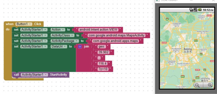
For example:
Show a map for a location
If you know a latitude and a longitude, you can use the VIEW action to show a map of the area:
Action: android.intent.action.VIEW
DataUri: geo:37.8,-122.23?z=10
The DataURI here specifies the latitude and longitude and also a zoom value of 10 (z=10). Zoom value is optional and ranges from 1 (the entire Earth) to 23.
Thank you for the explanation about maps. I tried with success the Activitystarer method and that gives me the Google Maps with English names. But I understand that the MAP tile from Mit app, alias OpenStreetMap, is what it is. I need the tap possibility to initiate collection of coordinates. I guess I have to live with it, but that's not too bad. For the time being my app will work as is.
Thanks again and I wish everybody much happy devellopment with MIT app inventor!
Because the OSM tiles are prerendered, they use the labels native to the region that is being rendered. They don't create permutations of the tiles for every language. So there's not much that can be done on that front. The other two tile layers come from USGS and might always show English, so you may want to try those but I can't guarantee they have sufficient coverage for your use case.
The Map component internally is designed to support multiple providers for maps, of which we currently only use osmdroid, an Android library for rendering tiles from OSM. I had the vision that we could also someday provide an implementation around Google Maps as well, but we don't have development resources to put into an effort that large. It's possible that someone in the open source community might want to pick this project up.
Hi, thanks for your reply.
I went to the help files of OSM and found this worldmap with latin names added. Can this map be used in stead of the map with local names? Should be a lot more convenient for many people. Can you take a look, please: OpenStreetMap