Salve a tutti,
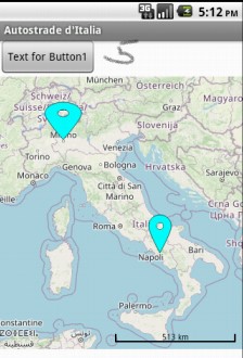
ho inserito tutte le coordinate di Lat e Long relative a tutte le autostrade italiane. Come si fa a visualizzare sulla mappa; solamente l'Italia? Nonostante io ho indicato Lat 42.5 e Long 12,5 relativa all'Italia; mi visualizza l'intero globo, con tutti i marker ovviamente ravvicinati 
Saluti
Nicola

You have to set the zoomlevel to what is right for you. Start with 15 for example.
Specifies the zoom level of the map. Valid values of ZoomLevel are dependent on the tile provider and the latitude and longitude of the map. For example, zoom levels are more constrained over oceans than dense city centers to conserve space for storing tiles, so valid values may be 1-7 over ocean and 1-20 over cities. Tile providers may send warning or error tiles if the zoom level is too great for the server to support.
1 Like
The documentation Maps tells you how.
ZoomLevel
Specifies the zoom level of the map. Valid values of ZoomLevel are dependent on the tile provider and the latitude and longitude of the map. For example, zoom levels are more constrained over oceans than dense city centers to conserve space for storing tiles, so valid values may be 1-7 over ocean and 1-20 over cities. Tile providers may send warning or error tiles if the zoom level is too great for the server to support.
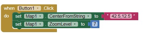
or ZoomLevel 5
depending on your device.
1 Like
This topic was automatically closed 7 days after the last reply. New replies are no longer allowed.