Hi, I'm a newbie in MIT app inventor, I found how can I open google maps, with a location, but I'm interested in how can I show it on the inline map tool? I found I can navigate with lat and lot values, but, my position is given with street number for example then how can I get this?
Welcome Sondor.
Try
Is that what you want to do?
1 Like
Hi @SteveJG! Thanks, for the answer, but not exactly this is what I'm looking for. This shows my location on the map, but I want to show a custom location, for example, Budapest, Kossuth tér 1 when the user is maybe in London, or who cares where. Or I want to put a pin there. If this is even possible.
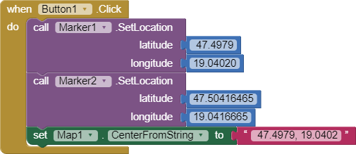
OK. Use a Marker and set its coordinates to:
Budapest             47.4979, 19.0402
Kossuth tér 1       47.50416465 ,19.0416665
to do this you have to know the latitude and longitude of the location.
This places two design time Markers as above and centers the display. Something similar can be done using runtime Markers and a List of coordinates
Hmm, this looks much more than what I want, thank You!
Then maybe I'll merge your code with this description about using external APIs with App Inventor and with google maps API for getting the given place geocoordinate.
Thank You!